Mnemonic Monuments
A Cartographic Art Study of Koresteia
Athanasia Tziona
The intersection of cartography and art allows for the representation of ‘invisible’ layers of a place, such as emotions, personal relationships, and memories [1]. In my creative practice I make artworks in the form of maps. They do not aim for topographical accuracy, instead, they function as mnemonic monuments; an attempt to structure a lasting tribute to a fading memory, where the history of the place is anchored and preserved.
My concept of the mnemonic monument draws on the potential of creative practice in connection with place and history. By creating artwork, a text, or even retelling a story we can be said to be building a 'monument' for that memory. Following the logic of Alfred Korzybski, who famously stated that "the map is not the territory" [2], these works acknowledge that representation is a subjective fragment of reality. The maps become a bridge between the physical, and the psychological landscape of nostalgia.
This article explores the intersection of memory, abandonment, and cartographic art through the study of Koresteia, a complex of abandoned mud-brick villages in Western Macedonia, Greece. Once vibrant mud-brick settlements, the villages were gradually hollowed out by the 20th century’s violent transitions: from the 1903 Ilinden Uprising and the clashes of the Macedonian Struggle to the devastating Greek Civil War (1946-1949), which led to mass displacement and left behind a landscape of silent ruins. By transitioning from a view from the ground to an aerial gaze, the practice-research transforms architectural decay into a symbolic language of paths. Utilizing local materials—specifically the red soil of the region—the artistic practice functions as a form of deep mapping, seeking to preserve the memory of a landscape in transition.
My first encounter with the villages of Koresteia, the ‘villages of oblivion’ as they are often called, was that of a passing traveler. The imposing presence of a mud-brick village appearing on the horizon captivated me; I had to stop the car and visit. It was impossible to simply pass by and continue my journey. I have no ancestral roots or prior connection to Koresteia, other than the profound emotion the landscape evokes in me. Every human trace on each abandoned building—every image bearing witness to the love, care, and craftsmanship of the people who built this community before being forced into uprooting—was imprinted on my mind with varying intensity and meaning. This experience drove me to focus on these villages during my Masters in Visual Practices at the University of Western Macedonia.
The Materiality of Oblivion
Every place carries untold stories, each person adding another layer to its narrative. [3]. The villages and landscape of Koresteia represent a unique architectural and cultural phenomenon in Greece [4], consisting of settlements constructed entirely of omoplinthoi (unfired mud bricks) [5]. These structures, made from a mixture of soil, water, straw, and goat hair, embody a fragile relationship between human habitation and the natural environment. These villages are not merely topographical points but narrative shells of a history interrupted by migration, war, and social displacement.
The settlements of Koresteia function as powerful landscapes where structures preserve an image of the past. (Figures 1, 2). While there is a physical absence of permanent residents today, cultural continuity persists through the villages’ official recognition as historic sites. Proposals for the area's revitalization seek to bridge the gap between the abandoned past and a possible future of re-habitation.
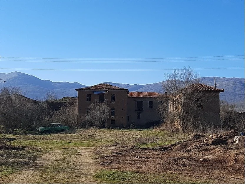
Figure 1: Athanasia Tziona, Korestia, Personal Archive Photograph, 2023
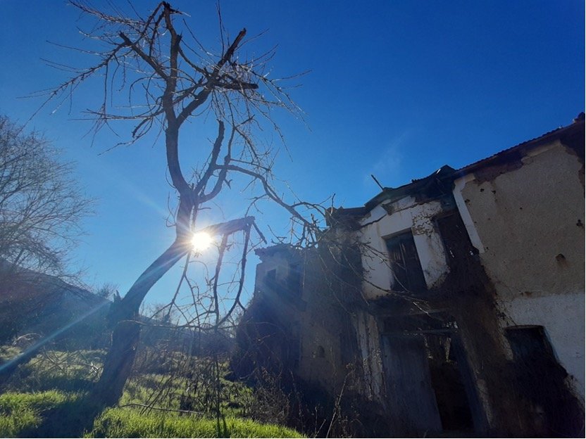
Figure 2: Athanasia Tziona, Korestia, Personal Archive Photograph, 2023
Perspectives of the Abandoned Places: From Existentialism to Synthesis
The ability to take photographs from above– first from balloons and airplanes, now from drones – has changed ways of seeing landscapes [6,7]. My investigation of the abandoned landscape is conducted through two distinct visual scales. Initially, the view from the ground offers an immersion into the texture of decay. At this level, the observer confronts the structural complexity of the mud-brick walls and the inevitable assimilation of human creation by nature. Drone photography allows me to capture the view from above, creating a shift in perspective, from embodied observation to cartography. While Michel de Certeau cautions that this perspective can create an illusion of power or alienation [8], in the case of Koresteia, it serves to reveal the hidden order of the ruins. From above, the individual house is subordinated to the ‘network’ in the paths and streets that once facilitated social cohesion, a trace of the repeated routes that the former inhabitants practised together (Figure 3).
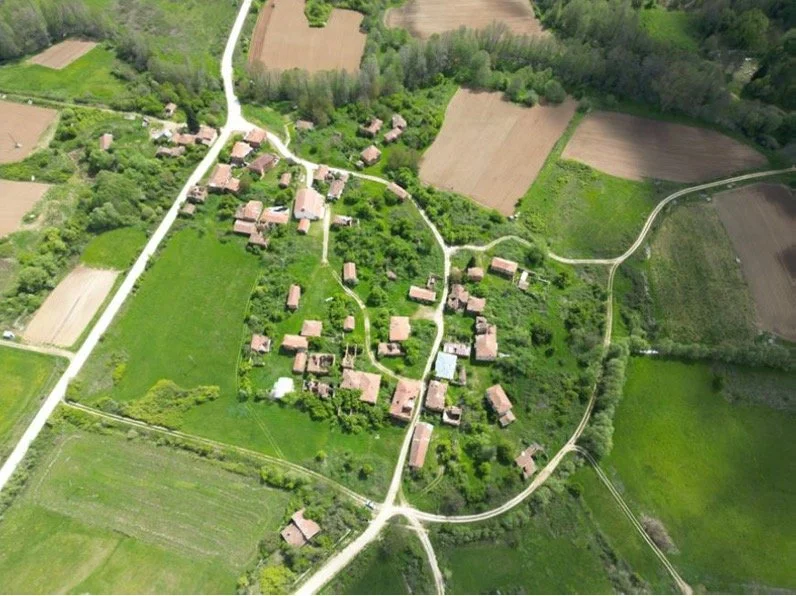
Figure 3: Athanasia Tziona, Korestia, Personal Archive Aerial Photograph, 2024
The Alchemy of Red Soil and Materiality
A central element of the artistic practice is the use of red soil, linen and reeds as primary media. This aligns with the importance of soil in architectural history and human creation, including in the building materials of Koresteia. The red soil provides a haptic quality to the work, ensuring a physical connection to the abandoned houses as a symbol of memory. This use of found materials and discarded objects echoes the practices of artists who utilize fragments to give voice to what is lost, creating a new perspective on what is truly significant. My focus in the map-works centres on the form of the road, the curving form that holds the village and networks its dwellings (Figures 4,5).
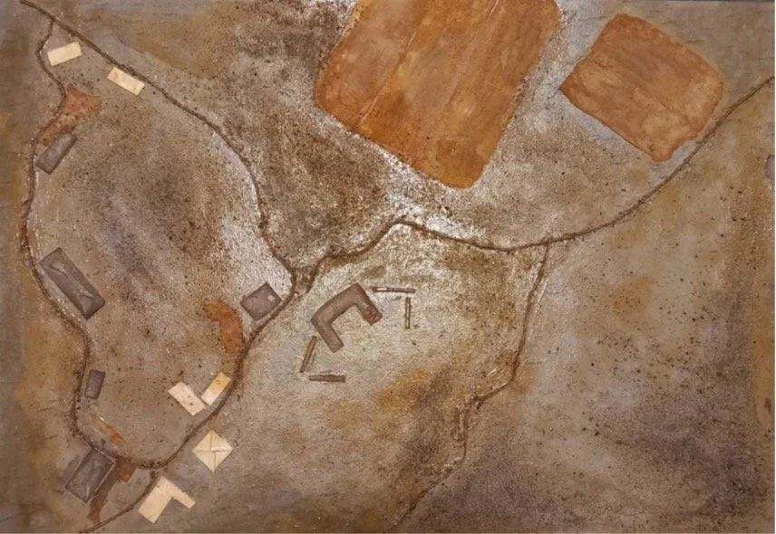
Figure 4: Athanasia Tziona, Untitled, 50 x 70 cm, sand, rope, gauze, cardboard, reed peels on cardboard, 2024
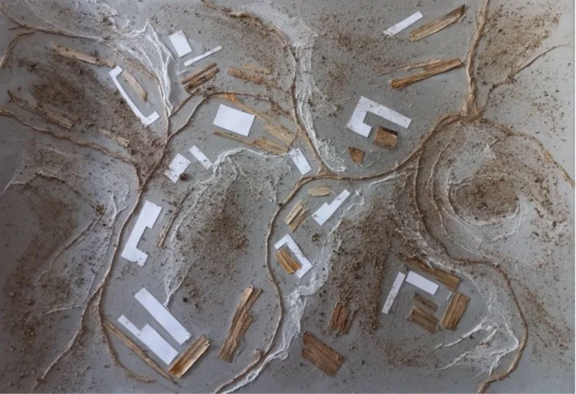
Figure 5: Athanasia Tziona, Untitled, 50 x 70 cm, sand, rope, gauze, cardboard, reed peels on cardboard, 2024
Using local reeds—traditionally a reinforcement material in mud-brick construction and agricultural work— I replicated the crossroad from the aerial view of the villages. In a floor-based composition, I further abstract from the aerial view to structure an image formed by the union of the village roads, worked in reeds and earth (Figure 6). This emphasises the common path of those who lived in the villages of Koresteia—a life that was forced to a sudden halt due to abandonment and migration. A diptych painting (Figure 7), takes this motif of the road’s form further, seeking to capture a reflection of memory of the village structure. The road motif symbolizes the memory of a shared life and journey. These function as an architectural elegy. As Paul Ricoeur notes, remembering is a way of declaring ‘I was there’ [9]. By mapping these streets with linen and reeds, the common path is highlighted, emphasizing that even in abandonment, the collective memory of human presence cannot be erased.
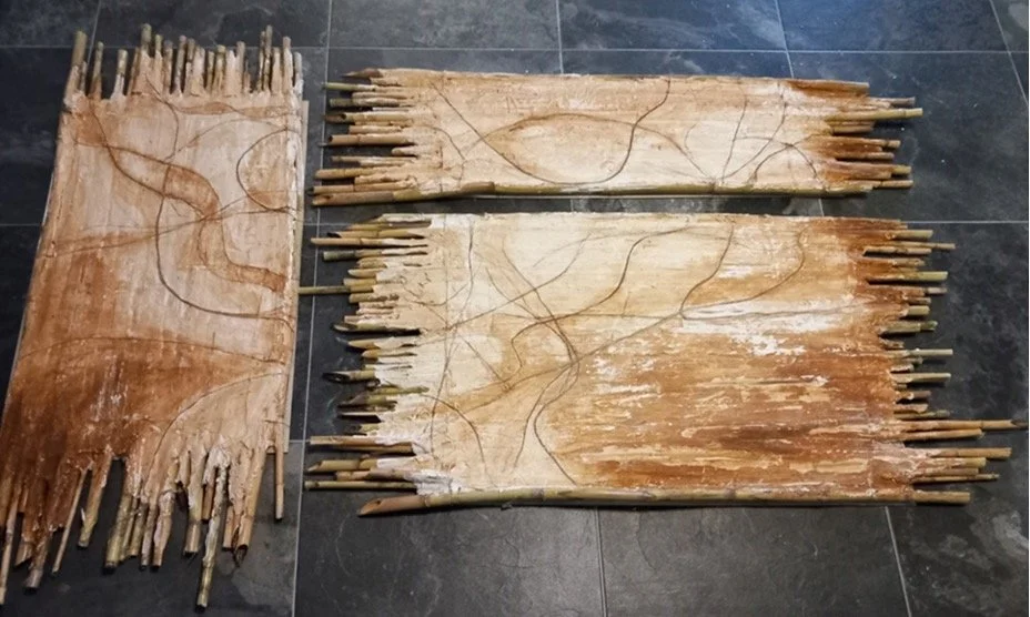
Figure 6: Athanasia Tziona, Untitled, 30 x 160 cm, 60 x 160 cm, 90 x 160 cm, red soil, flax (linen), reeds, 2024
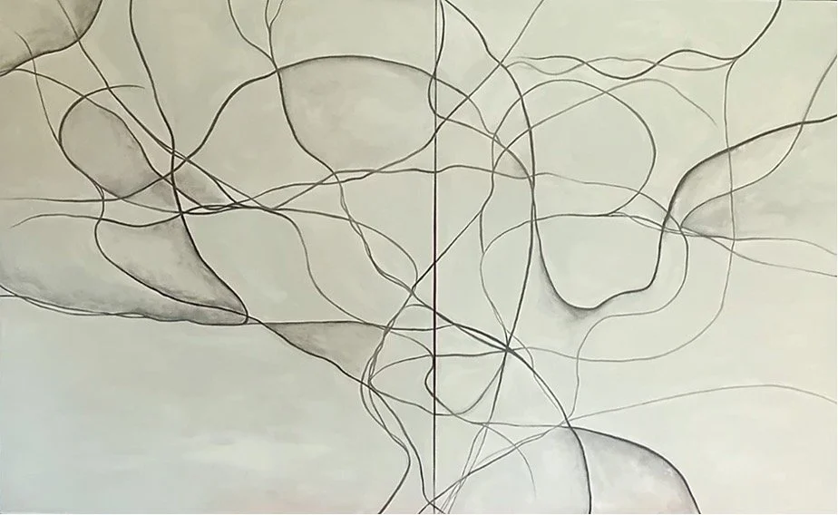
Figure 7: Athanasia Tziona, Untitled, 2 x 90 x 105 cm, acrylics on canvas, 2024
Conclusion
My approach to Koresteia – the collection of fragments, the use of local soil, and the mapping of paths – is an act of mnemonic monument-making. These artworks do not merely document a disappearing world, they serve as a counter to these villages’ oblivion through the passage of time, the fading of local memory and the silencing of the human stories embedded in the landscape. This work attempts to demonstrate that creative mapping can be a vital tool for understanding and actively remembering place, and for ensuring that the voices of the "villages of oblivion" continue to be heard.
Bio
Athanasia Tziona is an educator with a diverse background in Pedagogy, Special Education, and Psychology. She holds Masters degrees in Pedagogical Psychology and Visual Arts and Landscape. Her work bridges education and art through research on creativity, children’s artistic projects and group exhibitions. She is part of the European Funded Walking Arts and Local Communities (WALC) project.
Notes
[1] Harmon K. (2011). Introduction. In The Art of Mapping - Catalogue
[2] Korzybski, A. (1993). Science and Sanity: An Introduction to Non-Aristotelian Systems and General Semantics (5th edition). New York, USA: Institute of General Semantics.
[3] Pallasmaa, J. (2021). Δώδεκα δοκίμια για τον άνθρωπο , την Τέχνη και την Αρχιτεκτονική 1988 – 2018 (σε μετάφραση Αναστασία – Σάσα Λαδά & Κωνσταντίνος Ξανθόπουλος). Ηράκλειο: Πανεπιστημιακές Εκδόσεις Κρήτης
[4] Σινάνης, Α. (2015). Κορέστεια. Τα χωριά της λήθης. Τρίκαλα: Ανάβαση
[5] Μπαλασάς Α. (2016). O ιδιαίτερος μνημειακός πλούτος των Κορεστείων Καστοριάς και οι προοπτικές ανάπτυξης της περιοχής. Στο 8ο Διεπιστημονικό Διαπανεπιστημιακό Συνέδριο του Ε.Μ.Π. και του ΜΕ.Κ.Δ.Ε. του Ε.Μ.Π. : "Η ολοκληρωμένη ανάπτυξη των ορεινών και των γεωγραφικά απομονωμένων περιοχών" Μέτσοβο, 22-24 Σεπτεμβρίου 2016
[6] Cosgrove, D. (2005). Maps, mapping, modernity: art and cartography in the twentieth century, Imago Mundi 57 (1). 35–54 Doi: 10.1080/0308569042000289824
[7] Lanci, G. (2022). Art Maps and Cities. Contemporary Artists Explore Urban Spaces. Cham: Palgrave Macmillan.
[8] De Certeau, M. (1990). L΄invention du quotidien. Tome 1 : Arts de faire. Paris: Gallimard.
[9] Ricoeur, P. (2017). Architecture and Narrativity. Études Ricoeuriennes / Ricoeur Studies 7(2) : 31-42.
[10] Ζιώγας, Γ. (2020). H εικαστικότητα του Τοπίου, του Τόπου, του Χώρου. Μια τριπλή σχέση εικαστικής διάδρασης/και πέρα από αυτήν: το Πεδίο. Πανεπιστημιακές σημειώσεις του ΠΜΣ «Εικαστικές τέχνες και τοπίο: προσεγγίσεις του φυσικού και αστικού χώρου». Τμήμα Εικαστικών και Εφαρμοσμένων Τεχνών. Πανεπιστήμιο Δυτικής Μακεδονίας