Mpeehu za Bugungu
The winds and their influence on the life of the Bagungu people of Uganda
Kiiza Wilson
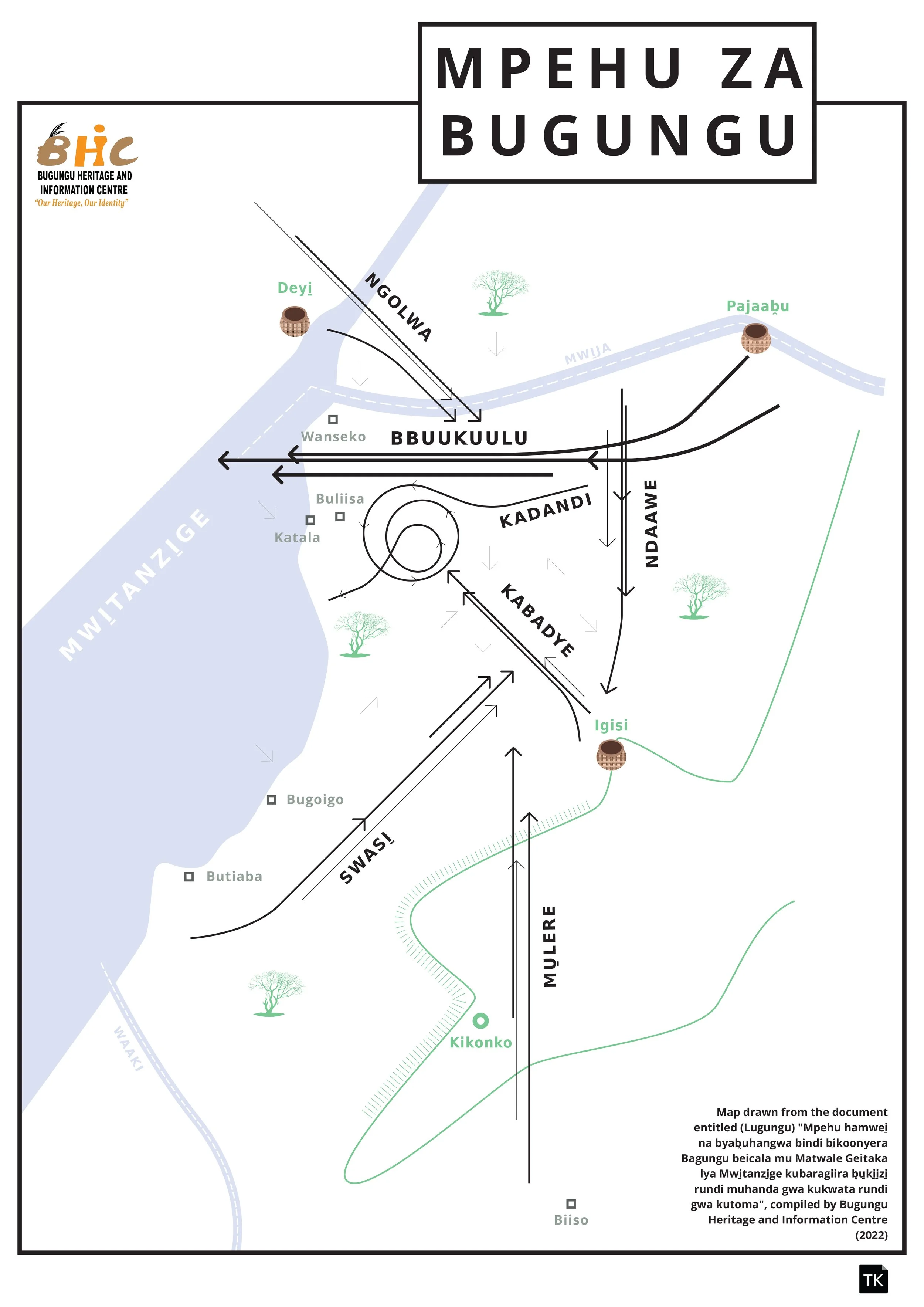
Our participation in the 2025 More-Than-Human-Mappings conference, organised by the Living Maps Network, was important to us in showcasing to the world how the Bagungu people of Lake Albert's north are influenced by the forces of nature. In this conference, our focus was on how winds influence the different spheres of the Bagungu people of Uganda. The Bagungu have names for each wind that blows in their ancestral territory. These include Ndaawe, Swasi̱, Kabadye, Ngolwa, Bbuukuulu, Mu̱lere and Kadandi. In times when there is no prevailing wind, it is termed ‘kamunda’.
The Bagungu believe that winds originate from the sacred natural sites (mpuuluma) and the custodians of these sites accept as true that when they offer sacrifices and make a request, their words and wishes are carried by the winds to the respective deity.
The Bagungu territory has a river and a lake, and fishing is one of the key activities. They fish on Lake Mwitanzige (Albert) and the river Mwija (Victoria and Albert Nile), and, for this activity, winds are very influential. When Swasi̱ and Bbuukuulu are prevailing, many fishermen will not go to fish because the waves are strong and can cause accidents and loss of nets. Through Indigenous local knowledge, the Bagungu can tell which wind is likely to prevail in the coming time by observing the clouds and touching the water. When the water is warm, it is an indicator that it is going to be windy, and the opposite is true when it is cold. Lightning and thunder are signs that it is going to be windy and hence alert fishers to work speedily and set off for home.
Swasi̱ is good for those who use basket traps as it brings fish to the lagoons where the basket traps are set. For those who fish from the River Nile (Mwi̱ja), it is only Swasi̱ that affects them since the waves from Lake Mwi̱tanzi̱ge can affect the movement of fish in the river.
Kabadye is a peaceful wind for the fisher. Kabadye is loved by the fishers because it is the only wind that stops Swasi̱. While in the lake, the oncoming of Kabadye is usually represented by a muddy smell, and this wind makes the water warm, and fish start to swim, increasing fishers’ chances of catching them.
The Bagungu also use wind to navigate their territory; they will give direction by telling someone to see the direction that a certain wind blows to or from. Each wind blows from a specific direction. For example, when someone says ‘look in the direction of Mulere’, they mean look to the South.
As a hunting community, when the hunters go to hunt and spot an animal, they first check which wind is prevailing. They approach their target from the direction the wind is coming from rather than where it is going to avoid their target smelling their scent and running away. The hunters will then go home after their hunting expedition, using the winds to give them direction. When hunting hippopotamus on the lake, Swasi̱ and other strong winds work in favour of the animals as hunters cannot easily travel on water to pursue them.
Farmers will also determine whether it is planting season depending on the winds. For instance, when Swasi̱ prevails, and it is replaced by Ndaawe, there is always lightning. This is a sign that it is going to rain. Ndaawe is famed for creating rain and is nicknamed Mugimba – rainmaker. The combination of four winds, Swasi̱, Ndaawe, Ngolwa and Bbuukuulu is believed to carry the rain from the skies and bring it down in a rowdy way, and Kabadye usually comes in to calm the situation so that rain is not destructive.
As cattle keepers, the Bagungu practice open grazing. While searching for the lost cattle, herdsmen will concentrate on the area opposite to the prevailing wind, as it is believed that cattle move in the opposite direction to the prevailing wind.
The Bagungu conduct trade mainly with the neighbouring Democratic Republic of Congo across Lake Mwitanzige. They use both winds and natural sites, for example, the mountains, stars, the moon, and galaxies for navigation; they can tell the popular stars which they associate with their homeland direction, like “Nyunyuzi mukaaga”, meaning a constellation of six stars which move together closely and a peninsula on Lake Albert to reach their destination.
Igisi Mountain in the present-day Murchison Falls National Park is the key feature which water travellers use when coming back from DRC, while Nyolya Hill in Zaire guides them while going there.
Ndaawe is common in January and February and is infamous for drying people’s skins and breaking their lips. It prevails mostly during this season in the search for rain, and it always dries out swamps.
In closing remarks, the above map shows the compass direction of each wind that blows in Bugungu territory, and the boldness of the line denotes the intensity of the wind. A pot on the map represents a Sacred Natural Site (SNS) which is seen as the places where winds originate from. At BHIC, we have undertaken research on the cultural heritage and history of the Bagungu people, established a community museum and library and heritage clubs in schools and supported cultural entrepreneurship through supporting weaving groups and troupes. Following the discovery of oil and gas in Bugungu, BHIC has stood as a hope for the preservation and protection of the cultural and environmental heritage of the Bagungu people. Despite the achievements, BHIC faces a number of challenges such as limited resources to implement projects and to pay wages, rent and utilities, and it is from this background that we call upon partners, donors and philanthropies to support us.
Bio
Kiiza is the Executive Director of Bugungu Heritage and Information Centre (BHIC), an organization that is dedicated to promoting and preserving community heritage of the Bagungu people. Kiiza is also a lead curator and researcher at Bugungu Heritage and Information Centre museum, a community museum based in Buliisa, Uganda. He holds Bachelor’s Degree in Development Studies. He is an alumnus of the prestigious Museum Lab fellowship of DAAD, as well as the Georgia University‘s African Civic Engagement Academy. Kiiza has interest in the cultural commons, decolonization and restitution and earth jurisprudence.